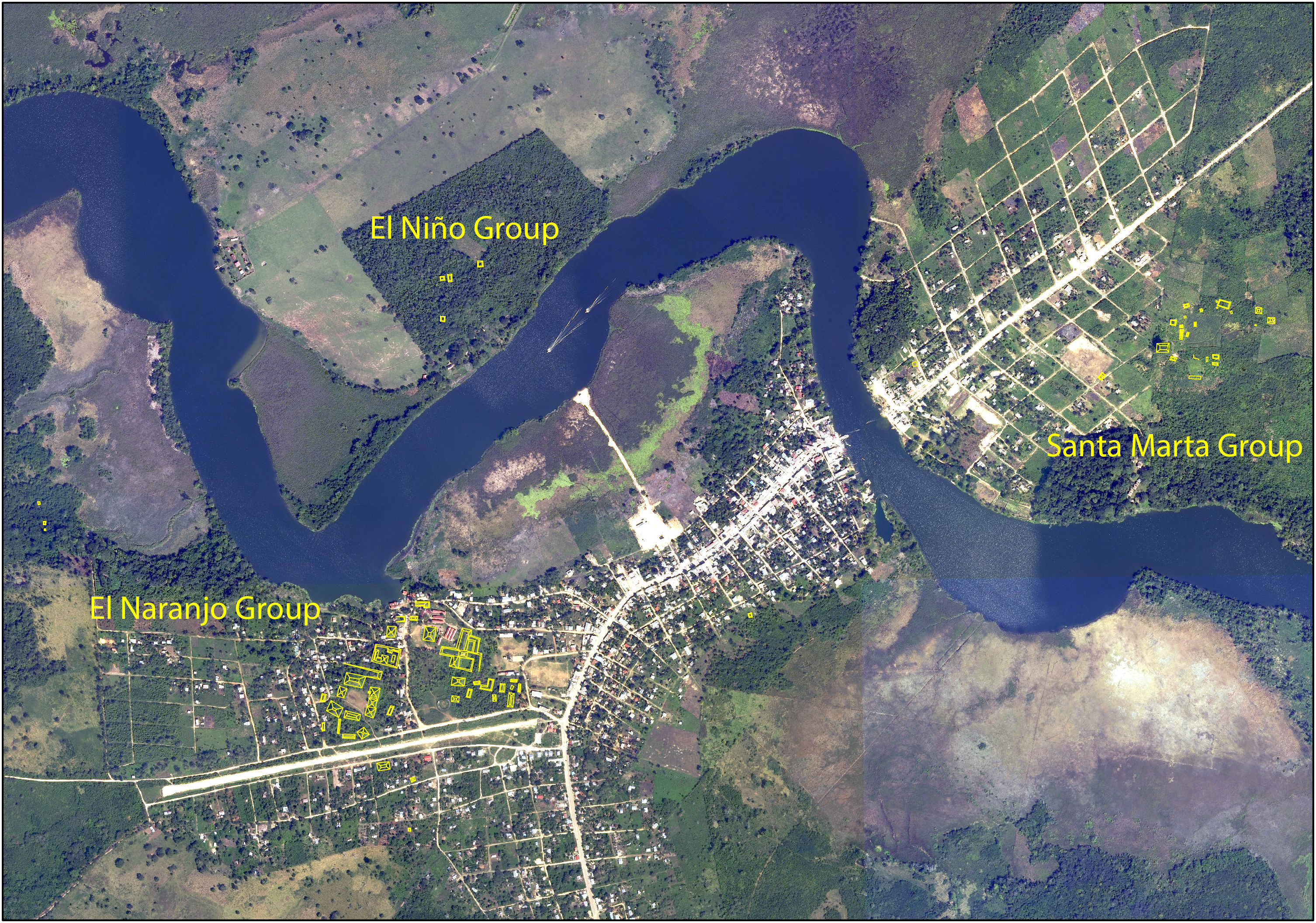
Our interest in the archaeological site of La Florida began in 2013 when we visited the site for the first time. We returned in 2014 to explore the site further and meet the local community. During our explorations, we realized that the site is composed of (at least) three different groups, arranged for maximum visibility of the San Pedro River.
2015 Season
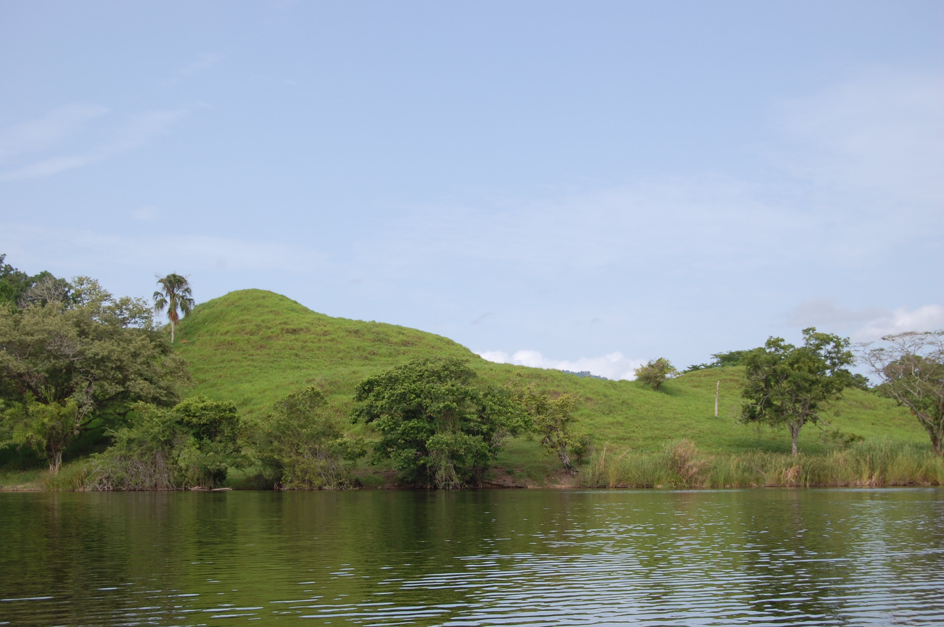
In 2015 we conducted intensive total station mapping of the El Naranjo Group, the largest of the three. While this area had previously been mapped by Ian Graham in 1965 and Paulino Morales in 1997, we updated their work, showing the relationship between the ruins and the modern town of El Naranjo.
The 2015 Season Report (Spanish).
2016 Mexicon Article (English).
2016 Season
The project conducted its first excavations in 2016, opening a series of test pits in plazas from around the site. We also conducted surface collecting and shovel testing in strategic locations. Preliminary ceramic data from these operations indicate that most of the construction at the site began after 550 A.D. We also found evidence for trade with the Tabasco Plain, highland Guatemala, and the Usumacinta River Valley.
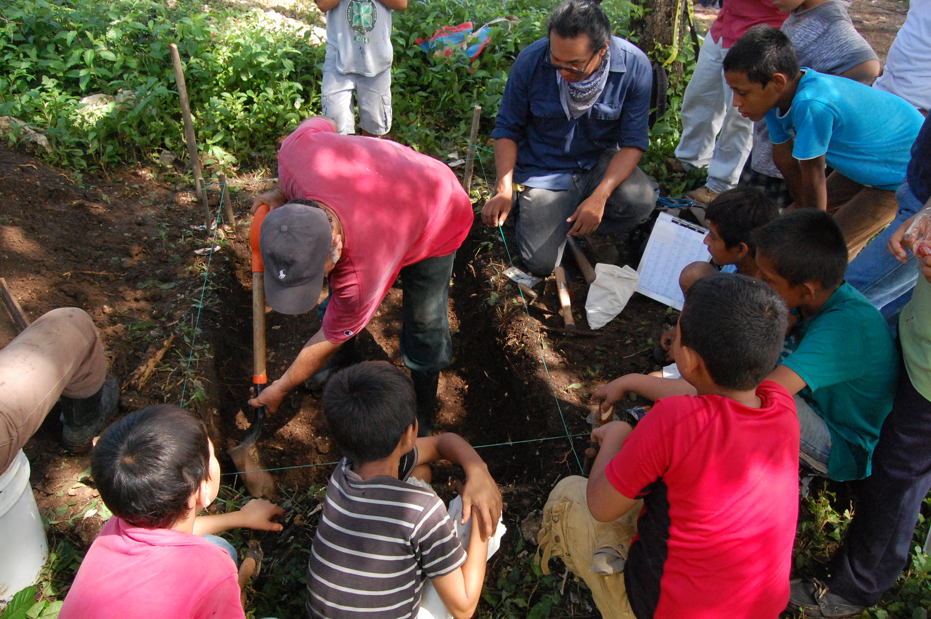
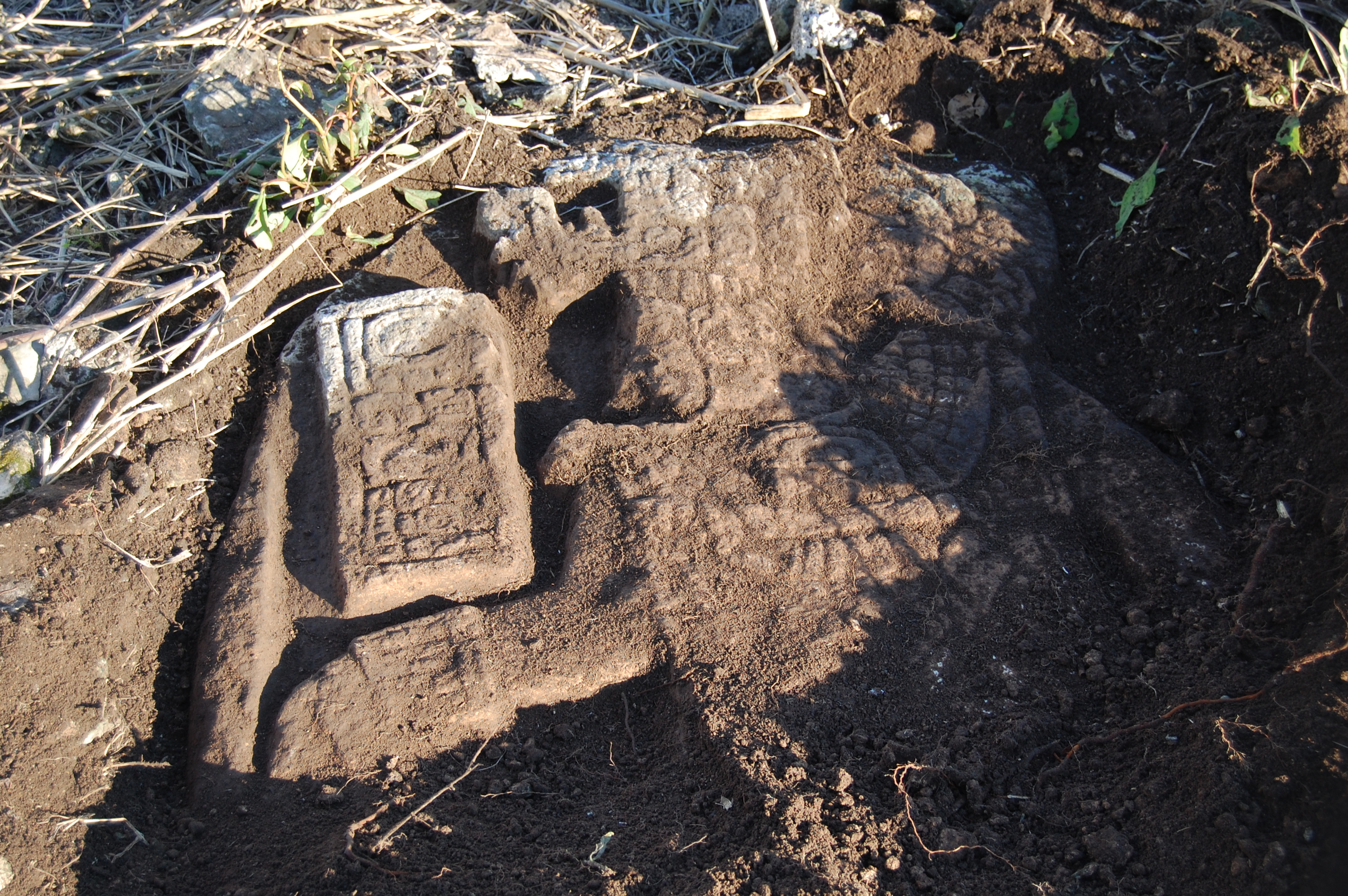
With the permission of local land owners, we conducted total station survey in the Santa Marta Group, updating our previous GPS maps of the area. During this mapping, we were surprised to find the corner of a carved stela emerging from the top of Structure R12-2. Once uncovered, this new Stela 16 proved to be the latest known monument at the site, dating to 785. With the support of landowner Benita Estrada and IDAEH, the stela was moved across the river to El Naranjo, where it is now under a protective roof with other stela for public study and appreciation.
The 2016 season report (Spanish).
A preliminary interpretation of Stela 16 (Spanish)
2017 Season
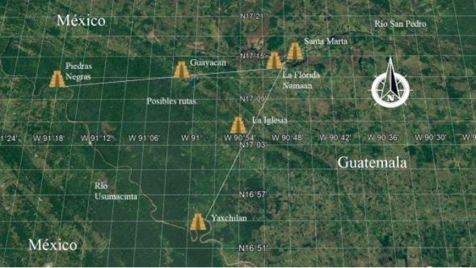
During the 2017 field season, we conducted survey along the San Pedro River to the east and west of the site. Don Alfredo Morales, Auxiliary Mayor of El Naranjo, also allowed us to explore his parcel of land to the south of the site in the foothills of the Sierra Lacandon mountains. Here, several caves overlook a pass giving access to the San Pedro River Valley. Ceramics in the caves indicate that they were occupied and, we suspect, were used to strategically control passages through the foothills. We plan to continue exploration in future seasons. Finally, we had the opportunity to study and record a carved fragment of Stela 6, which Paulino Morales had discovered in 1996. Our study indicated that the stela dated to 652 A.D., the earliest yet known at La Florida. See “Epigraphy” for more details.
The 2017 season report (Spanish).
2018 Season
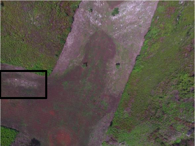
The 2018 season focused primarily on the excavation of Structure O14-4 in the “Los Caballos” patio group and on the exploration of a group of caves known as “La Iglesia.” Excavations on O14-4 revealed that the structure was built in phases, originally facing a small patio group to the north, but later additions altered the primary orientation of the structure. We plan to continue excavations in this elite residential group in upcoming seasons. “La Iglesia” is a collection of caves and rock shelters located southwest of La Florida in the direction of Yaxchilan. We began explorations of this area in 2017, but were unable to explore the largest of the identifiable caves. In 2018, we conducted explorations of this cave, whose church-like appearance gives the entire group its name. Recovered ceramics indicate a Late Classic occupation, though a handful of earlier sherds were also recovered. Most interestingly, drone photography revealed the presence of a low rectangular building at the base of the hill where the large cave is located. We hypothesize that the area was occupied as a point of control between the San Pedro and Usumacinta River valleys, particularly for the inhabitants of La Florida to monitor any hostile approach from the site of Yaxchilan.
The 2018 season report (Spanish).
2019 Season
During the 2019 Season, we continued excavations in the “Los Caballos” patio group, exposing the final phase of structures O14-3, O14-7, and O14-5. We recovered utilitarian and polychrome pottery, grinding and cutting stones, and a ceramic ear flare. The artifacts recovered in this group so far indicate that it was constructed during the Late Classic period. We also began working with an aquatic drone, equipped with sonar and GPS, in order to map the river bottom at the El Naranjo group. While no clear underwater features have been discovered so far, the drone proved a useful tool for mapping the underwater topography.
The 2019 season report (Spanish).
For more information about project data, please contact us at florida.namaan@gmail.com.
Datos Arqueológicos
Nuestro interés en el sitio arqueológico La Florida empezó en 2013 cuando visitamos el sitio por primera vez. Regresemos en 2014 para explorar más y conocer la comunidad de El Naranjo. Durante estas exploraciones, nos dimos cuenta de que el sitio se compone en al menos tres grupos, todos construidos con una vista al Río San Pedro.
Temporada 2015
En 2015 mapeamos con la estación total en el grupo El Naranjo, lo mas grande de los tres grupos. Mientras esta zona había sido mapeado anteriormente por Ian Graham en 1965 y por Paulino Morales en 1997, agregamos nuevos detalles y incluimos la relación entre las ruinas y el pueblo actual de El Naranjo.
El Informe de la temporada 2015.
Un Articulo en Mexicon 2016. (Ingles).
Temporada 2016
El proyecto hizo sus primeras excavaciones en 2016, abriendo una serie de pozos, pruebas de pala, y recolección de superficie en lugares estratégicos. Datos preliminares de la cerámica recuperada indican que las plazas excavadas se iniciaron después de 550 d. C. Encontramos evidencias cerámicas por intercambio con las regiones de Tabasco, tierras altas, y el Río Usumacinta.
Con el permiso de los dueños, mapeamos con la estación total en los terrenos del grupo Santa Marta. Durante este proceso, nos sorprendimos en encontrar la esquina de una estela tallada saliendo de la estructura R12-2. Destapada de la tierra, esta estela resultó ser el monumento mas tardío conocido de La Florida, fechando al año 785. Con el apoyo de la dueña del terreno, Benita Estrada, y del IDAEH, la estela se traslado al otro lado del rio a El Naranjo, donde esta bajo un techo protector con las otras estelas, para que el público lo puede estudiar y desfrutar.
El informe de la temporada 2016
Una interpretacion preliminar de la Estela 16
Temporada 2017
Durante la temporada 2017, hicimos recorridos del Rio San Pedro al este y oeste de La Florida para registrar estructuras. También, Don Alfredo Morales, Alcalde Auxiliar de El Naranjo, nos dejo explorar su parcela al sur del sitio en los cerros de la Sierra Lacandon. Aquí, varias cuevas tienen vista de un valle dando acceso al Rio San Pedro. Cerámica hallada en las cuevas indica que habían estado ocupado y creemos que los Mayas las usaban estratégicamente para controlar caminos entre los cerros. Esperamos seguir exploraciones aquí en el futuro. Finalmente, tuvimos la oportunidad estudiar y registrar un fragmento de la Estela 6 que había hallado Paulino Morales en 1996. El estudio reveló que la estela probablemente tiene la fecha 652 d.C., la fecha más temprana de La Florida. Vea “Epigrafía” por más información.
El reporte de la temporada 2017
Temporada 2018
La Temporada 2018 se enfocó pincipalmente en la excavacion de la Estructura O14-4 del grupo patio “Los Caballos” y en la exploración de un grupo de cuevas llamado “La Iglesia.” Excavaciones en O14-4 revelaron que la estructura se había construido en fases, originalmente con su frente hacia un patio al norte, pero más tarde modificado con una adosada que cambió la orientación del edificio. Esperamos continuar excavaciones en este grupo residencial elite en el futuro. “La Iglesia” es una colección de cuevas y abrigos rocosos ubicada al suroeste de La Florida hacia el sitio Yaxchilan. Empezamos investigaciones de esta area en 2017, pero sin poder entrar en la cueva más grande. En 2018, hicimos exploraciones en esta cueva, cuyo semejanza a una iglesia da nombre a todo el grupo. Cerámica recuperada indica una ocupación del Clasico Tardio, pero unos tiestos más tempranos también fueran hallados. Más interesante, fotografía por drone reveló la presencia de un edificio rectangular muy bajo en la base del cerro en que se ubica la cueva grande. Creemos que la area fue ocupado como un punto de control entre los valles del río San Pedro y el río Usumacinta, especialmente para evitar qualquier llegada de fuerzas hostiles de Yaxchilan.
El informe de la temporada 2018
Temporada 2019
Durante la temporada de 2019, continuamos las excavaciones en el grupo “Los Caballos,” exponiendo la fase final de las estructuras O14-3, O14-5 y O14-7. Hallamos cerámica utilitaria y policroma, piedras de moler, pedernal, obsidiana, y una orejera de barro. Los artefactos recuperados en ese grupo indican que fue construido durante el clásico tardío. Tambien empecemos trabajar con un dron acuático, equipado con sonar y GPS, para mapear las partes sumergidas del rio San Pedro. Aunque no hemos hallado estructuras sumergidas hasta ahora, el dron se puso útil en entender la topografía subacuática.
El informe de la temporada 2019
Por mas información sobre los datos del proyecto, por favor escríbenos a florida.namaan@gmail.com.